Building a Eastern Road Models “CNR Double-Ended Transcona Shop Snowplow” in HO Scale: PT 1

Steve Hunter’s very own Double-ended plow, built from his own kit. Photo and model by Steve Hunter.

It’s been a busy and just plain overwhelming summer and fall, which has not left me with a lot of time or capacity to build.

But, with things calming down and signs of winter starting to appear, I figured that it might be an appropriate time to build the Eastern Road Model’s CNR Double-ended Snowplow kit I’ve been sitting on for a few years.

For those unfamiliar, Eastern Road Models was the moniker Steve Hunter used for his PEI prototype-focused Shapeways 3D printed model shop.

CN built a small handful of these Double-ended plows at the Transcona shops in the 1930s, and while they could be seen elsewhere in the system from time to time, I am all but sure they were built with PEI in mind; they could be seen on the island right up until abandonment.

The body and cupola are shown as primed before any detailing. Yes, my bathroom has the best lighting in the house once the sun goes down.

The body and cupola are supplied as separate purchases, and the rest is up to the modeller to source and more or less figure out.

Sparing a novel, essentially up to this point in the build, what I have accomplished is as follows:

  • Prepared the Shapeways parts by leaving them in an ultrasonic bath filled with a mixture of Simple Green HD and water.
  • Sanded the body of print lines and removed any excess wax material from the printing process.
  • I drilled for the grab irons and other necessary holes.
  • I primed the body and cupola.
  • Applied Micro-Mark rivet decals to the body and cupola (has to be closing on 1000 rivets).
  • Bent all grab irons from scratch, including the drop grabs, using .010” PB wire.
  • Installed the brake wheel and staff.
  • Installed the wire, receptacles and snow shields for the snowplows power connections with the locomotive.
  • Installed hinges on the journal box access hatches using Grandt Line reefer hinges.

All that remains is the installation of the roof grabs around the cupola, stove stack, horn, headlights, paint, decals, couplers.

Hoping to get this finished off before Christmas.

Calvin

Vernon River Co-Op Warehouse: a study on shared building plans.

IMG_1210

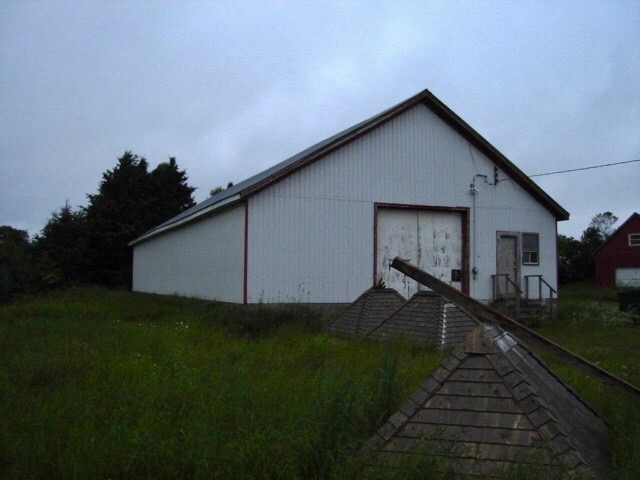
The former Vernon River Co-Op Warehouse built in 1947. July 2013. Chris Mears photo, used with permission.

Since the very conception of this layout, a mystery has been at the back of my mind. That is the mystery of the Vernon River Co-Op Warehouse.

Perhaps not as much of a mystery as a minor annoyance. You see, the photos I have are only but a tease only providing partial views of how this building looked while it was still rail-served.

There is one fact working for me: the building still stands today- rails to trails use it as a workshop. Having an accurately sized model will not be a problem; however, its freight doors and roof vents have been removed, and the roof and siding have been replaced.

I’ve reached out to local area Facebook groups to find a better photo of the building with its freight doors still intact, to no avail. I’ve reached out to the archivist at St. F.X. University, which does have a giant photo collection of Co-Op buildings, PEI included- to no avail. (One avenue I have not yet explored is to contact rails to trails and see if I could be allowed inside to see if the door framing is still visible.)

This information gap has mostly left me to fill in the blanks myself.

However, just this morning, I had a bit of an “ah-ha” moment.

I don’t know why this didn’t hit me before now, but I had already been aware of direct evidence that the co-operatives routinely shared building plans, being co-operatives and all. One such example is the Co-Op Potato Warehouses at Morell, Tignish and Souris being nearly identical.

Could the Vernon River Co-Op warehouse be a shortened version of these other warehouses?

IMG_1199

Morell’s Co-Op Warehouse. Year and photographer are unknown. St. F.X. University Archives.

20935076_1902309463423996_4088096629602011681_o.jpg

Souris Co-op Warehouse. Steve Hunter photo, year unknown.

IMG_1209 copy

Tignish’s Co-Op Warehouse. Year and photographer are unknown. Note that the building is nearly identical to Morell’s warehouse, a county away.

What caught my attention is how similar the front of the Morell warehouse looks to the front of the Vernon River warehouse. The large double door and loft door are of identical construction. The chimneys are similar. While in different locations, the man-door and window are of very similar structure. What we can see of the first freight door shows us that these doors are also very similar, if not identical, to the Morell warehouse.

To corroborate my theory, I took to Google Earth and went back in time to 2015, when the Morell warehouse still stood. Now, the two warehouses’ lengths obviously differ- we don’t need Google to tell us that, but I was most interested in finding out if the buildings were the same width.

I’ll be the first to tell you that Google Earth’s measurements aren’t always so accurate (they even admit this themselves). Still, I figured that if I measured the buildings from a satellite image taken on the same day, I’d be able to figure out if they were the same size.

What I came out with was this:
Morell warehouse= 43.24′ x 122.82′
Vernon River warehouse = 44.91′ x 82′

Given Google’s inaccuracies and satellite imaging variables, the widths are very close indeed. I’ll take that as a win.

So now we know that the Vernon River and Morell warehouses were, in all likelihood, the same width. The similar width dimension, look, owner, and use of the building make me feel comfortable using the Morell and Souris photos as a reference for the Vernon River build. The Morell and Souris photos, along with a scale drawing of the Morell warehouse Steve Hunter gave to me, will most certainly get me most of the way there.

Without a photo showing the Vernon River warehouse’s entire side, we don’t know how far apart the two freight doors were.

I can figure this out in two ways:
– Obtain permission to enter the warehouse as it stands today and see if the door framing is still visible from the inside.
– Measure the outside of the warehouse and use the 1958 air photo to scale out the door centres.
These methods will have to wait until the snow melts, but I’m happy having figured out the process I’ll have to follow.

One final question I may never have a firm answer on involves the relationship between the truck door and the foundation.

In the Souris, Tignish and Morell photos, the land is built up to the top of the foundation to meet the truck door- meaning the truck door doesn’t go through the foundation. However, in the Vernon River photos, it appears as if the foundation has been cut to allow for a taller truck door. The man door placement above the foundation caught my suspicion and made me believe that the ground was initially built-up like the other warehouses. For some reason, the door’s height needed to be increased, so the foundation was cut to allow for this.

As you can see in the 1981 Vernon River photo, it looks as if a whole new door frame has recently been installed and the earth around the foundation excavated. The man door remains above the foundation. Perhaps this is all the evidence I need.

After studying the images, I have concluded that it’s very likely that at some point, the foundation was cut to accommodate a taller truck door- most likely in the early 80s. Wouldn’t the man door be cut into the foundation if the building was initially built like this? I feel confident I can model the door as shown in the Morell photo, with it being accurate.

Unfortunately, I’ll have to wait until the spring to further this research as it requires a field visit. Still, I feel confident that I have most of the information I’ll need to scratch-build this building.

If you’ve stuck with me this long, thanks for reading.

CM

A sunny winter’s day prototype visit.

After Wednesday’s hangout with Taylor, Chris and David I was feeling pretty pumped about the direction of things.

That feeling was only amplified after a Saturday afternoon spent in New Brunswick operating on Doug Devine’s Island Central Railway and Steve McMullin’s Carelton railway.

Even though we we’re very much in the dead of winter here on Prince Edward Island, spring was definitely in the air this Sunday afternoon. I couldn’t resist making the first of what is likely to be many visits to the prototype location.

I can look at photos all day but to catch onto the feeling of the layout I really needed to get out to Vernon River its self and get an idea of how the land lays in 1:1.

Instead of photos, I thought it would be easier to just make a short video which you can find right here:


I will return when the snow melts and again in the summer. I plan to take many photos of the right of way,  trees, buildings, farmers fields and farm roads in the area to get a good idea of how I’ll model them.

C.M.

Vernon River / Murray Harbour Subdivision traffic analysis [PT:2 Researching Traffic Amounts and Crunching the Numbers]

7751 on Murray Harbour Sub CN002589
44 Tonner #7751 leads a mixed train on the Murray Harbour Subdivision. #7751 was renumbered #2 June 1956. Photographer unknown. CSTM Collection (#CN002589)

In my previous post I used newspaper archives to determine and describe the types of traffic I thought Vernon River would normally see.

My goal is now to not only determine the amount of freight traffic Vernon River would see but to also determine the average train length, loads and percentage of originating vs terminating traffic on the Murray Harbor subdivision as a whole. Having these statistics will allow me to accurately model the car movement both through and at Vernon River.

This info is important for a few reasons, but mainly I need to be able to:

  • Determine in general terms the amount of switching moves per operating session
  • Determine to the average train length through Vernon River
  • Determine the usual ratio of originating to terminating cars
  • Use the above information to figure out how long the single track staging cassette will need to be on each side of the layout.

With the new Drive-By Truckers record on in the background, into the rabbit hole I went.

In my files I found a summary written by Shawn Naylor of a freight report CN completed in the early 1960s. Apparently this report was prepared to propose reductions in PEI’s rail service. In the report CN used carload data from the mid to late 1950s which makes it super conveniently accurate for my layout’s era.

Below I’ve created a spreadsheet of carload data as it applies to the Lake Verde, Vernon [Loop] and Murray Harbor subdivisions from this summary (the same mixed train #240N / #209S served these subdivisions.)

1958 Daily Carload Data: Lake Verde, Vernon [Loop], Murray Harbor Subdivisions

STATION

ORIGINATING CARLOAD / DAY

TERMINATING CARLOAD / DAY

TOTAL

Millview0.4NIL0.4
Vernon [Loop]0.51.01.5
Murray Harbor0.10.10.2
Mount Albion0.6NIL0.6
Other Lake Verde, Vernon and
Murray Harbor 
Subdivision Stations
2.00.72.7
TOTAL3.61.85.4
If you’re not familiar with island railroading it’s important to note that “Vernon” and “Vernon River” are two different locations. I’ve marked Vernon with [Loop] to make it less confusing.

Using the numbers on the chart it would be fair to say the average train could include around five freight cars- a pretty low key operation. Most photos I’ve seen reinforce this, showing on average zero – three freight cars plus the baggage and coach car. [With a train so small I should be able to get away with a 5ft staging cassette on each side of the layout]. Obviously not all of these cars would be destined for Vernon River. In fact, it probably wasn’t a daily occurrence that anything would even be switched there. For the sake of fun, my layout will only operate on days where there is an originating or terminating load for Vernon River.

Knowing the average train length I now need to know what types of freight we’d see on that train. Naylor’s summary includes traffic types for the Murray Harbor, Lake Verde and Vernon [Loop] subdivisions but the figures are irrevocably lumped together with the Montague and Georgetown subdivisons. I can live with that though- the Montague and Georgetown subdivisions would have seen pretty similar types of traffic. It shouldn’t distort our reality too much.

1958 Originating vs Terminating Carloads: Murray Harbor, Vernon [Loop] & Lake Verde Subdivisions:

  • Originating Carloads: 67%
  • Terminating Carloads: 33%

1958 Originating Carloads: Murray Harbor, Vernon [Loop], Lake Verde, Montague and Georgetown Subdivisions:

  • Potatoes: 57%
  • Turnips: 33%
  • Other: 9%
  • Livestock: 1% (Aprox 13 carloads per year)

1958 Terminating Carloads: Murray Harbor, Vernon [Loop], Lake Verde, Montague and Georgetown Subdivisions:

  • Other: 54%
  • Sand and Gravel: 27%
  • Fertilizer: 13%
  • Coal and Coke: 3% (Aprox 30 carloads per year)
  • Animal Feed: 2% (Aprox 27 carloads per year)
  • Petrol Products: 1% (Aprox 9 carloads per year)

In Naylor’s summary is it said that a contributing factor to PEI’s high operating costs was the need to use different cars for originating and terminating traffic; cars used to import things to the Island tended to leave empty. As such, local moves will range from very rare to non-existent on this layout.

With these statistics I now have a great foundation to base my layouts operations around. Even though I’m only modelling a single village, I think its important to consider the subdivision as a whole in order to serve my chosen village accurately. 

Now I just need to figure out how to work these averages and percentages into a car card system…

CM


Vernon River / Murray Harbor subdivision freight traffic analysis [PT. 1 Researching Traffic Types]

With a prototype chosen it was time to dive a little further into my research.

My first goal was to figure out the types of freight traffic the village would see in a broad sense and not just my chosen era; after having that information I could then, through logic and evidence, figure out what would be applicable to my era.

One of the primary tools for the research job was islandnewspapers.ca. – “a fully-searchable online archive of PEI’s main newspaper of record, The Guardian, from 1890 to 1957.” This archive along with a document by Shawn Naylor that Steve Hunter passed to me a few years ago provided me with a wealth of information.

What I found was that Vernon River received quite a few different commodities ranging from general merchandise to mussel mud. Its main exports would have been produce (potatoes likely being the majority of this) and livestock (mainly hogs). 

I have compiled the following list of inbound and outbound traffic. Everything listed is based upon direct evidence (unless marked with a “*” or “**”) found in newspaper archives or in Naylor’s document. 

  • Outbound Traffic:
    • Produce (Potatoes, Turnips and other crops)
    • Livestock (mainly hogs but also cattle)
    • Finished Wood (*) (not likely in my era)
  • Inbound Traffic:
    • Animal Feed
    • Limestone
    • Fertilizer
    • Bulk Oats
    • Barley
    • Bulk Wheat
    • Fuel (**) (would oil and gasoline be pumped from tank cars into trucks to supply farmers with fuel?)
    • Coal (OCS and revenue)
    • Ties (OCS)
    • Mussel Mud (not likely in my era)

(*) Outbound loads of finished wood is a assumption at this point and only that. This is based on the existence of a saw mill about half a km away from the station. While I have not found any evidence to back up this assumption I don’t think it would be much of a stretch to consider them using the public siding to ship finished wood at some point. I have not found much information on the saw mill and it’s hard to tell in my air photos if it exists in a operational capacity in my era. 
(**) There is no evidence I have found of fuel being received at Vernon River. Would it be possible that fuel would be pumped from a tank car into a truck to deliver to farmers? The farmers had to get it somehow and even still by the late 1950s not all of the roads east of Charlottetown had been paved. I am genuinely not sure how this worked.

Based upon the list above its easy to imagine the types of rolling stock the village would have received, namely lots of reefers, boxcars and stock cars. 

Next time I will delve into the research of the daily amount of carloads both originating and terminating (along with their types) to try to get a sense of what a switching job at Vernon River consisted of.

Thanks for reading,
-CM